
6 Intriguingly Shaped Communities As Seen On Google Maps
The introduction of mapping applications such as Google Maps (undoubtedly the most popular example of all) and their subsequent widespread use around the world has resulted in an enormous amount of people taking up an interest in an interactive view of the world which previously was very difficult to obtain. There are millions of incredibly interesting sights to experience which, when living at ground level as we do, are rarely seen in the flesh.
As an example, here are some intriguingly shaped communities which take on a new appearance when viewed from the air, along with those same areas pinpointed in embedded maps. Take a look around.
Trails West, Arizona
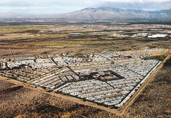
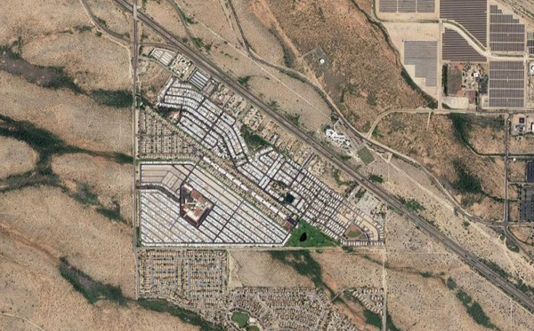
(Above) To begin, here’s a small mobile home community called Trails West just outside Tuscon, Arizona. The interesting thing about it is the shape as there aren’t many towns or communities with such a distinctly triangular boundary.
Sun City, Arizona
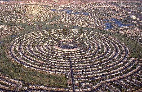
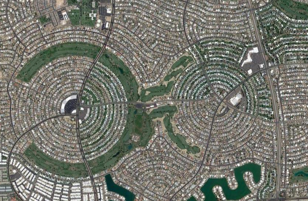
(Above) Sun City is a planned retirement community in Arizona which, due to its design and hundreds of identical houses, offers an incredible view on Google Maps. Dozens of tightly knit roads snake around the area and even form a couple of huge circular neighbourhoods.
Ixtapaluca, Mexico
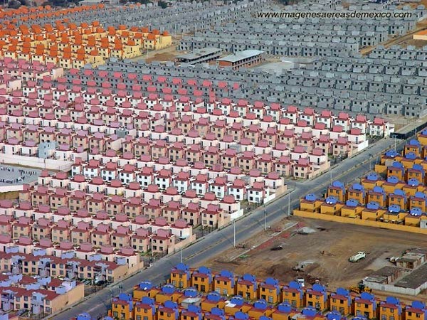
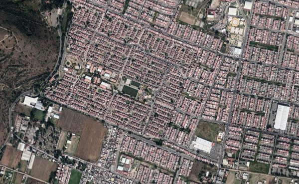
(Above) The town of Ixtapaluca in Mexico is full of low-income housing identical to the examples you see in the photo above, resulting in rows and rows of cookie-cutter homes which resemble a cartoon-based community. From above, the area is just as uniform and equally as fascinating.
Bourtange, Netherlands
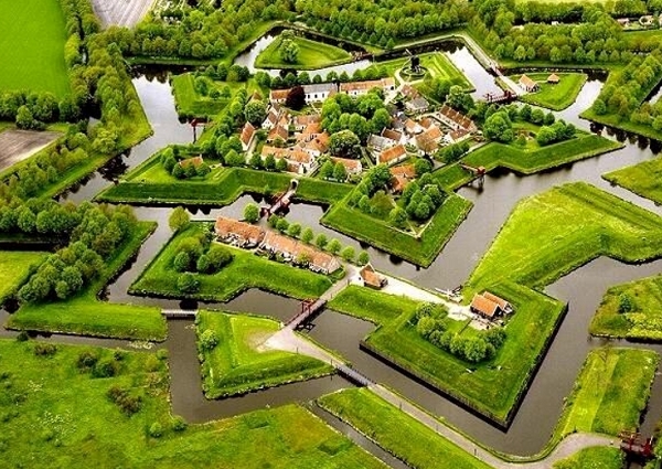
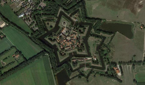
(Above) The beautiful star-shaped village of Bourtange was originally built as a fort in the 1500s, the shape chosen due to its highly effective defensive qualities. Today it houses a village and museum and looks incredibly unique, especially when viewed from the air. There are a few other similarly shaped villages around the world but none as defined as this one.
Harborwalk, Texas
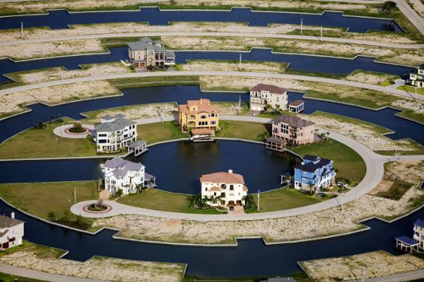
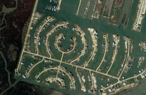
(Above) Developers in Galveston decided to build a planned community on the wetlands in Galveston and came up with a strange design where houses sit on rings of land which, from above, resemble concentric ripples on the water. At the moment the town is still under development, hence the numerous gaps where homes should stand.
Palm Islands, Dubai
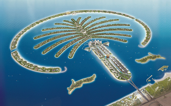
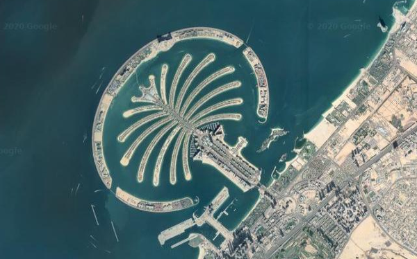
(Above) The award for Most Eccentrically Shaped Community has to go to Palm Islands in Dubai, an incredibly ambitious project which will, if ever completed following the financial crisis, consist of 3 separate palm tree shaped islands off the coast. Work on the first island began in 2001 and can be seen on Google Maps. The size and scale of the project is astounding.
Nice collection of interesting places of the world! Amazing!
I liked the “Bourtange, Netherlands” It’s green. And very nice star
http://maps.google.com/maps?t=k&q=53.016667,7.183333&ie=UTF8&source=embed&ll=55.681553,12.597799&spn=0.03518,0.11158&z=14&iwloc=A
Pingback: Hageby ekstrem at Klimaetaten
Pingback: Garden City i kubik at Klimatdepartementet
What about Naarden in The Netherlands? Looks kinda like Bourtange.
Unusual shapes indeed. The Google maps views are amazing.
Pingback: Sekmadienis su StumbleUpon #81 ? Radiocool.lt
Pingback: byisk wrzucił link na Flakera | flaker.pl
Palm Islands – my favourite 🙂
@szuman that one has had the most clicks.
Hello to everyone from Wykop.pl, thank you very much for visiting my website. Feel free to say hello.
An interesting shaped city I visited while living in Italy is Palmanova, http://maps.google.com/maps?ll=45.905191,13.31217&z=16&t=h&hl=en
A gdzie zatoka czarwonych świń w Warszawie?
Real amazing, especially palm island! 😀
Pingback: dead bee season - monday monday
Pingback: Formas Intrigantes | Coió Online
Pingback: Lugares interessantes
Bourtange looks like heaven on earth. If I were to be rich in funds I would copy it for myself and a few others.
Apparently the water in the Palm Islands is rancid because it can’t flow properly in and out to the ocean.
Very nicely researched…Bourtange would make an excellant final hole in the ultimate golf course!!
How about the capital of Brazil?
Google Maps view, a drawing and a photo from a real plane, as opposed to a city shaped as one 🙂
Trackback: meneame.net
Pingback: Daily Digest for June 17th | Half-baked
One unfinished project is missing: The World islands, also in Dubai. It’s quite visible in satellite view in Google maps:
http://maps.google.com/maps?q=dubai&oe=utf-8&client=firefox-a&ie=UTF8&hl=en&ll=25.222801,55.171108&spn=0.079977,0.218353&t=h&z=13
Built by Germans in now Polish city Wrocław, in a shape of an eagle:
http://maps.google.com/maps?f=q&source=s_q&hl=pl&geocode=&q=wroc%C5%82aw&sll=51.107941,17.099361&sspn=0.100234,0.2211&ie=UTF8&ll=51.109665,17.100649&spn=0.012529,0.027637&t=k&z=15
Better seen from an angle:
http://www.klimczewski.nazwa.pl/sky/eagle.gif
Pingback: The Daily Dig - ‘Slap in the Face’ Edition » INFRASTRUCTURIST
Pingback: Daily Digest for June 18th | Half-baked
Pingback: Six Intriguingly Shaped Communities @ Blog @ dfwNepal.com
really great photos, i want live there! 🙂
Pingback: Lake Panopticon, a suburban paradise at ryangs.net
In BadÃa del Vallés (Catalunya, Spain) there is a small village shaped as Spain itself, being the streets named as the mountains, rivers, etc of our country.
See it at http://maps.google.es/maps?ie=UTF8&ll=41.509172,2.114975&spn=0.008838,0.022745&t=h&z=16, or http://fronterasblog.files.wordpress.com/2009/04/badia_espanya.jpg
Pingback: “Got Empties?”
I suggest some a places in Italy,
Palmanova.
@Giovanni that one is awesome, thanks for posting 🙂
I Love this one: Bourtange, Netherlands
Very similar to some of nintendo games
Location Number 2 — it is a bike!
@Lee I see it, either that or some crazy eyes.
Yeah, Alex MacLean has some really fantastic aerial photos of planned communities around the US. Some of them are pretty creepy, actually. On his website click “Portfolio” then “Dwelling” http://www.alexmaclean.com/
Ah, didn’t see one of his made the list… These terraformers have taken things to a whole new level.
Pingback: Links for 6/24/2009 | Jason Clarke
Pingback: Sun City Arizona Snowbird Getaway | I Like My Web Golf News .com
Pingback: links for 2009-06-28 | burningCat
Pingback: Links para Lolo » Blog Archive » Algunos Links para Lolo
Excellent article,well written with great reference pictures and the addition of Google map links topped the cake.
Pingback: 15-Aug-2009 | MohanArun.com
Very similar to some of nintendo games
LOL..”nintendo games”
Some amazing photos, I’m left wondering with a few how the people find their own house?!
Really interesting articles. Are these genuine images or has the artwork been touched up they are truly. Thanks for sharing a nice info.